Showing posts with label National Parks. Show all posts

Tuesday, August 16, 2011

Salinas y Aguada Blanca National Reserve


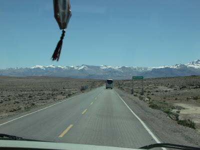
To get from Arequipa to the Colca Valley one leaves the city and skirts around Chachani volcano, following the Arequipa-Juliaca highway, and then takes the turn-off toward Colca.  On the way to Colca one must cross the Salinas y Aguada Blanca National Reserve.

The reserve encompasses 366,936 hectares and contains a number of fresh- and salt-water lakes and ponds -for which it is named- plus bogs and other high-altitude wetlands, as well as dry puna, volanic deposits, and snow-capped volcanoes. It was created in 1979 in order to protect the fauna, flora, and natural landscape of the area, and in particular to preserve habitat for vicuñas and guanacos - wild relatives of the domesticated llamas and alpacas.


The average elevation is above 4,000 meters a.s.l. - for example, at one spot where we stopped for a break the elevation was 4,225 m. (13,861 ft. a.s.l.), and at the Mirador de los Volcanes the road passes 4,910 m. (16,108 ft. a.s.l.).  Having been in Arequipa for a couple of days already seemed to have helped a bit with the altitude.
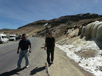

ICEFALL


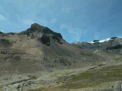
At one point along the way the road passes through the blown-out caldera of an extinct volcano.  While that's pretty impressive in itself, it is made even neater by a rather large icefall beside the road.


VICUÑAS


For the visitor, even ones just passing through, one of the primary attraction of the national reserve of Salinas y Aguada Blanca is the chance to see some wild vicuñas.

The vicuña is a wild cousin of the llama and the alpaca, and is one of two nondomesticated South American camelids - the other being the guanaco, which also inhabits the reserve but is rarely seen.  Vicuñas wool is among the finest in the world, and a garment made from it can easily fetch (US)$1000 or more.  The vicuña population in Salinas y Aguada Blanca is managed by the peasant communities within the reserve, who annually gather the animals for shearing, and patrol the reserve against poachers the rest of the year.

We were lucky enough to spot vicuñas both, on the way to, as on the way from, Colca.


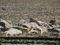
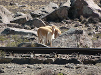
 Vicuñas live in small herds of one male and a handful of females.  Young males are kicked out of the herd, and wander for a while, until they establish herds of their own or they are strong enough to chase off another male and take over his harem.


Which means that this individual was likely a male a year-old or thereabouts.


VIZCACHAS

Another animal which occurs at those altitude, and which is normally quite shy as well, is the vizcacha.  Being usually described as similar in appearance to a rabbit, but really being much more like a chinchilla, vizcachas nest in crevices and spaces in between and under rocks throughout the Peruvian Andes.   They are sometimes hunted for their pelts and for food.

We were lucky, on our way back to Arequipa, to catch some sunning themselves on the rocks piles that had been left from clearing the roadbed through the Patapampa plateau, at above 4,800 meters a.s.l. (15,750 ft.).


Wednesday, July 23, 2008

Huascarán National Park

After breakfast on Friday we rented a 4x4 pickup truck and headed north through Huaylas valley, our primary destination being the lakes at Llanganuco in Huascarán National Park.


On the way we stopped in Carhuaz, a town known as the "Land of Ice Cream," where we sampled artisanal ice cream flavors such as chirimoya, maracuyá, peanut, the strongest rum-raisin we'd ever tasted, and even beer-flavored ice cream...


as well as some real beer:


Passing Yungay, we turned east and upward into the Cordillera Blanca, the snow-capped range on the eastern side of the valley, and toward Mt. Huascarán.


Once we left the highway, the road turned to a dirt track, which was so pitted and bumpy that it took a good 45 minutes to make the climb the 4000 feet to the park entrance. It was an uncomfortable ride for all, specially those riding in the truck bed.

The Llanganuco valley lies within the National Park, at 12,630 feet above sea level. It is a glacial valley flanked on the south by Mt. Huascarán (Peru's highest peak, at 22,205 ft) and on the north by Mt. Huandoy (20,853 ft), whose snowmelt feeds two lakes which are the valley's main attraction. We stopped by the shores of the first lake, Chinancocha.


Unfortunately, several of the kids were affected by the reduced oxygen level, suffering from headaches and being generally ill-at-ease. Their symptoms were somewhat eased by cupfuls of a coca and muña-leaf tea and papas rellenas (stuffed potatoes).


Somewhat revived by the snack, we opted for a light lunch of a mix of roasted guinea pig, chicharrones, boiled corn with cheese, or fry-bread, all prepared on-the-spot over a wood fire.


Nico declared the picante de cuy he ate the best guinea pig dish he'd ever tasted, and the fry bread, called cachanga, was pretty darn good, but the chicharrones were fatty and bony, and left a lot to be desired in both flavor and price. Still, the setting could hardly be improved...


Saturday, August 18, 2007

"La Catedral" in Paracas


This is La Catedral - The Cathedral- an impressive stone formation in the Paracas Natural Reserve, a peninsula south of Lima and quite near the epicenter of this week's 8.0 earthquake.

For years La Catedral has been one of Paracas' main attractions, not just because of its impressive double arch, but also because of the vault that gives it its name.


Along the southern side of the peninsula there is a long arching beach at the foot of seaside cliffs. The there water is so rough and the currents so treacherous that the local fishermen named it Supay, which means "devil" or "demon" in Quechua.

In 1976 I camped on that beach for a week with my Boy Scout troop, Jesus Maria #82, and La Catedral was one of the wonders we discovered for ourselves.

The land approach is from Supay beach, and through a small door-like opening in a cliff, as can be seen in this photo from a visit I made in July of 2002 with my children, my cousins Jose Alberto and Juancho, his wife, Cristina, and their daughter, Rafaela.

Susana, Jose Alberto, Cristina, Rafaela, Nicolas, and my cousin Juancho
at the entrance to La Catedral


Passing through the entrance and through a short passageway, one suddenly came into a large vaulting cavern, open to the sea.


From the cave the double arches could be seen and the noisy colonies of sea birds observed - as long as one kept an eye open for incoming waves! If one was patient and quiet for long enough, soon sea otters' heads would pop up out of the water to observe their visitors.

The Catedral was carved by immense forces, as evidenced by the massive boulders which littered the leeward side of the cavern. This week, that process -which undoubtedly took many thousands of years- took a drastic leap forward: the earthquake caused the main arch to collapse, sealing the cavern and doing away with a true natural wonder.


More Images from Machu Picchu

From L to R: (Standing in back) Juan Ramon, Nicolas
(Middle row) Peter, Betty, Ben, Ceci, Benji, Taysha, Susana
(Front row) Adrian, Pali, Betty Susana, Guille


Site map given to us at the gate


The mountains surrounding Machu Picchu.
The peak at right is Mt Yanantin.


Terracing down the western slope, at bottom is the Urubamba River


The "Mortars"
The purpose of these is unknown. Hiram Bingham supposed them to be mortars, but archaeologists now believe that, filled with water, they were used as mirrors, but for what purpose is still open to speculation


A reconstructed hut near the Ceremonial Rock


The Artisans' Wall and Group of the Three Doorways, in the Western Urban Sector


The Artisans' Wall
If you look closely at this image and the one above you may be able to notice a small opening half-way up the wall between the two sets of windows. It is a drainage duct built into the wall by the Incas, and example of the care with which they designed their cities


The Eastern Urban Sector, with the Royal Enclosures at front

The famed Temple of the Three Windows overlooking the plaza


The Torreon