Tuesday, August 30, 2011

Colca 3: Cabanaconde


On our night in the Colca Canyon (July 29th), we stayed in the town of Cabanaconde, which is the seat of the district of the same name, in Arequipa's  Caylloma province.

Beside condors, Cabanaconde is known for the exquisitely embroidered traditional clothing worn by its women.   It contrasts from the also highly decorated clothing of the women of Chivay in that the latter employ apliques of sequins and beads to achieve the decoration while Cabanaconde women exclusively use embroidery.


 There is also a legend related to Cabanaconde that concerns the Incas.  It seems that the Inka Mayta Capac   arrived one day with an "army" and built terraces in the valley.  There, this "army" build terraces and planted corn at various levels, and once it had sprouted,  departed, ordering the local Cabana people to not touch the crop until the Inka's return.

Seven years passed until Mayta Capac returned with another "army", this time of farmers, who harvested the ears.  The corn had in the intervening years differentiated itself into seven varieties adapted to different conditions in the valley, and thus gave rise to the Cabanaconde corn, which is famed for its quality throughout the south even today.


Part of the view from our hotel

Ruins of an old private chapel, as seen from the hotel balcony

 We spent the night at the Hotel Kuntur Wassi, a place of somewhat ecclectic-seeming design, but friendly service and good food - I had a terrific lomo saltado there (and if you recall what I said previously about eating lomo saltado out you'll understand that this was quite something) and we were treated to a welcoming cocktail, and an after-dinner digestif from a selection of cane liquor macerated with Andean and Amazonian herbs.

An interesting feature of our night there was that the beds were dressed with thick hand-woven wool yarn blankets and the air was so dry and the static electricity so strong up there that in the middle of the night's darkness sparks would flash whenever one rolled over in bed!

It was nice to fall asleep to the baah'ing of the sheep next door and the hee-haw'ing of the donkeys across the way.


Cabanaconde lies near the western, downstream, end of the Colca Canyon and across the valley from the western flank of Bomboya mountain.  The mountain is sadly in the Peruvian newsmedia a lot these days thanks to the disappearance four or five months ago of Lima university student, Ciro Castillo.  His then girlfriend, Rosario Ponce, was found by rescuers after wandering alone on the mountain, she says, for nine days since she and Castillo argued and went their separate ways.   Since the start there were questions raised about Ponce's testimony and the behaviour of the couple in the day, or days, previous to their purported separation.   In any case, Castillo's dad has been roaming the mountain since, hoping to locate his son's body, Ponce has been tried in the media, and the case is the talk of the town throughout the the region.

We departed Cabanaconde early on the 30th of July, after a morning stroll and visit to the plaza.


Friday, August 19, 2011

Colca 2: Choquetico

On the 29th of July the eleven of us, plus my infant niece, who had traveled to Arequipa ventured into the Colca Valley.   We had hired a van to take us to the town of Cabanaconde and back to Arequipa on the following day.   After passing through the Salinas y Aguada Blanca National Reserve, over the high puna at Patapampa, and through the mountain passes, we descended into the valley near the town of Chivay.  After lunch in Chivay we headed down the Colca Valley toward the canyon carved by the Colca River and toward Cabanaconde.

One of the sightseeing stops along the way was at a locale called Choquetico, near the town of Pinchollo.  The attraction of the stop at Choquetico -which is simply a stop at the shoulder of the road and a peek over the edge of the cliff- is a pair of carved boulders.


Choquetico is something I had not know about until I noticed what looked like a representation of a carved boulder on a model of the Colca Valley in Arequipa's Museo Santuarios Andinos.  My interest piqued, I made sure to ask our driver about it and was pleased to confirm that indeed we would be stopping there.

The reason for my excitement was that what I expected to see, and indeed did see, was an ancient carved boulder made to resemble the terracing on the slopes opposite, on the other side of the river, or at least what they looked like in pre-Inca times.


There are a few similar image stones scattered throughout the Peruvian Andes, perhaps most famously at Saywite.  They were apparently instrumental in fertility or rain ceremonies directed at the earth.   

If one looks at the photos one will notice the presence of a well atop each stone, with channels leading from it.   It seems that chicha or llama blood were poured into the well until it ran down the channel to the terraces carved into the stone, as water from the mountains above would flow down the slopes to water the agricultural terraces.  In "watering" the stone's terraces the priests thus symbolically watered the valley's slopes.


Overlooking the site are a pair of tombs placed high up on a cliff.   They would be nearly invisible but for the red paint applied by the ancients - in the Andes red was a color assiciated with nobility (the Inca royal "crown", for example, was a red tassel at the forehead).  Bothe tombs were sacked long ago, but their presence underscores the sacred nature and ritual nature of the site to the ancient Collaguas -as the people who inhabited the valley before the Incas arrived were known.

Wednesday, August 17, 2011

Colca


After about three hours on the road, we suddenly descended from the heights of Patapampa into the Colca Valley, near the town of Chivay.  Chivay, at the eastern, and upriver, end of the valley, is the economic and administrative hub of the area.  There, one must buy a Colca "Tourism Ticket".


That seems like a bit of an imposition, since one is simply paying to enter the valley, and the roads are public after all, but the regional government has allowed the Colca communities a certain autonomy in running local affairs and permitted them to impose that fee on tourists, so it is as it is.


Near Chivay

At this point, the Colca Valley is just that, a valley. It's a highly agricultural area, and nearly every available hillside is covered in agricultural terracing, some predating even the Inca presence in the valley.


Near Pinchullo

It isn't until near the town of Pinchullo that the river has carved out its famous canyon.   By then -shortly outside of Chivay, in fact- the road asphalt runs out and the road turns to one of packed-earth, until it nears Cabanaconde, our destination at the other end of the canyon.    At this time of year -winter, and the dry season- the road was bumpy, dusty, and slow, but traversable.  I'd hate to imagine what it woud be like at the height of the rains in January or February!


Cantuta blossoms.  Peru's national flower.

Near Cruz del Condor

At Cruz del Condor

Tuesday, August 16, 2011

Volcano Alley

There is a string of volcanoes in southern Peru that runs from the department of Moquegua in the south, up through Arequipa, and ending in the southern provinces of Ayacucho.   Part of that stretch, a bit to the north of the city of Arequipa,  is known as Valley of the Volcanoes.

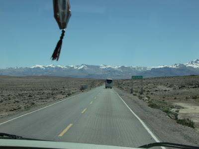
The road to the Colca Valley from Arequipa does not pass through or near the Valley of the Volcanoes, but at a stretch along the Arequipa-Colca highway, across the plateau of Patapampa, one can not only glimpse the southern extremity of the valley, but on a clear day one can take in about 20 snowcapped, mostly volcanic, peaks.


On the left are the volcanic summits of Mt Ampato -where the naturally-mummified body of an Inca girl, subsequently nicknamed "Juanita"-  was found, and Mt. Sabancaya.  On the right is Hualca Hualca.

In the photos above, you may notice piles of stones.  Those are apachetas, offerings left by travellers at the high passes as a gesture to the wamanis or apus of the mountains.   There are a lot of them at this spot because, not only is it the high point of the road - 4,910 meters (16,108 ft) above sea level- but it is also a stopping point for viewing the vista of volcanoes, known as the Mirador de los Volcanes.

Liz the Explorer, at the Mirador de los Volcanes.  Behind her in the distance is Mt. Chachani.


Salinas y Aguada Blanca National Reserve


To get from Arequipa to the Colca Valley one leaves the city and skirts around Chachani volcano, following the Arequipa-Juliaca highway, and then takes the turn-off toward Colca.  On the way to Colca one must cross the Salinas y Aguada Blanca National Reserve.

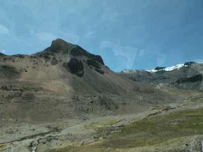
The reserve encompasses 366,936 hectares and contains a number of fresh- and salt-water lakes and ponds -for which it is named- plus bogs and other high-altitude wetlands, as well as dry puna, volanic deposits, and snow-capped volcanoes. It was created in 1979 in order to protect the fauna, flora, and natural landscape of the area, and in particular to preserve habitat for vicuñas and guanacos - wild relatives of the domesticated llamas and alpacas.


The average elevation is above 4,000 meters a.s.l. - for example, at one spot where we stopped for a break the elevation was 4,225 m. (13,861 ft. a.s.l.), and at the Mirador de los Volcanes the road passes 4,910 m. (16,108 ft. a.s.l.).  Having been in Arequipa for a couple of days already seemed to have helped a bit with the altitude.


ICEFALL


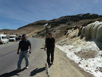
At one point along the way the road passes through the blown-out caldera of an extinct volcano.  While that's pretty impressive in itself, it is made even neater by a rather large icefall beside the road.


VICUÑAS


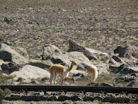
For the visitor, even ones just passing through, one of the primary attraction of the national reserve of Salinas y Aguada Blanca is the chance to see some wild vicuñas.

The vicuña is a wild cousin of the llama and the alpaca, and is one of two nondomesticated South American camelids - the other being the guanaco, which also inhabits the reserve but is rarely seen.  Vicuñas wool is among the finest in the world, and a garment made from it can easily fetch (US)$1000 or more.  The vicuña population in Salinas y Aguada Blanca is managed by the peasant communities within the reserve, who annually gather the animals for shearing, and patrol the reserve against poachers the rest of the year.

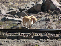
We were lucky enough to spot vicuñas both, on the way to, as on the way from, Colca.


 Vicuñas live in small herds of one male and a handful of females.  Young males are kicked out of the herd, and wander for a while, until they establish herds of their own or they are strong enough to chase off another male and take over his harem.


Which means that this individual was likely a male a year-old or thereabouts.


VIZCACHAS

Another animal which occurs at those altitude, and which is normally quite shy as well, is the vizcacha.  Being usually described as similar in appearance to a rabbit, but really being much more like a chinchilla, vizcachas nest in crevices and spaces in between and under rocks throughout the Peruvian Andes.   They are sometimes hunted for their pelts and for food.

We were lucky, on our way back to Arequipa, to catch some sunning themselves on the rocks piles that had been left from clearing the roadbed through the Patapampa plateau, at above 4,800 meters a.s.l. (15,750 ft.).


Friday, August 12, 2011

Yanahuara


About 1.5 miles from the city center liesYanahuara, a district of the province and of the city of Arequipa.  Yanahuara is a mainly middle-class area which is known as one of Arequipa's more "traditional" and picturesque neighborhoods.  Many of its buildings, particularly in the area known as "Yanahuara Vieja" (Old Yanahuara), are constructed from white sillar stone, amongst them the Church of San Juan Bautista, on Yanahuara's main square.

Church of San Juan Bautista (1750)


The Church of San Juan Bautista (i.e., St. John the Baptist) was built in 1750, with an addition completed in 1783.   With it's ornate carved sillar entryway, it is often regarded as one of the most representative examples of mestizo Baroque architecture in the area.

Liz and I at the mirador, with Misti volcano in the distance.
Next to the park and church there is a mirador, or lookout point, comprised of a sillar arcade, decorated with inscribed quotes from famous arequipeños.  From the mirador all of dowtown Arequipa can be glimpsed, along with the three volcanoes - Chachani, Misti, and Pichu Pichu- at whose feet the city lies.

The view from the mirador.
Chachani is on the L, Misti in the center, and Pichu Pichu on the R.

Arequipa is famed throughout Peru for its cuisine and mongst Yanahuara's other attractions are a number of well-regarded picanterías, or restaurants where traditional, old-style regional foods are served.


Clockwise from top L: Chupe de camarones (crayfish stew), and Liz at picantería Sol de Mayo;
spiced pork and beef steaks at Picantería Nueva Palomino;  Kola Escocesa (Scottish Cola), a regional soft drink;
Arequipeña beer; Chicharrón de camarones (deep-fried crayfish) with fried yuca, at Nueva Palomino.